
View from High Rocks, Dunmore Pine Barrens/Gravity RR Preserve
I awoke before 5 am and was soon out the door. The clear morning skies motivated me as I drove to the trailhead. My goal was to see the sunrise at a vista I had never been to before.
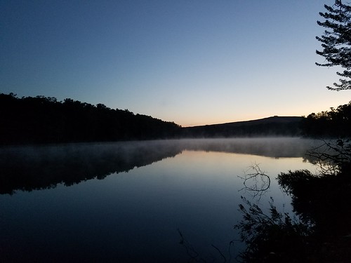
I parked off the street, next to a gate at the Dunmore Reservoir No. 1 and took a quick photo of the still water with its veil of mist, providing a perfect reflection. With the help of my cell phone as I navigated my way to the vista, I followed a gated, paved road up the hill with views of Scranton. Light began to grow across the sky with shades of red and orange. The gated, paved road ended and I hurried across a meadow speckled with wildflowers, not to mention some deer, and more views.
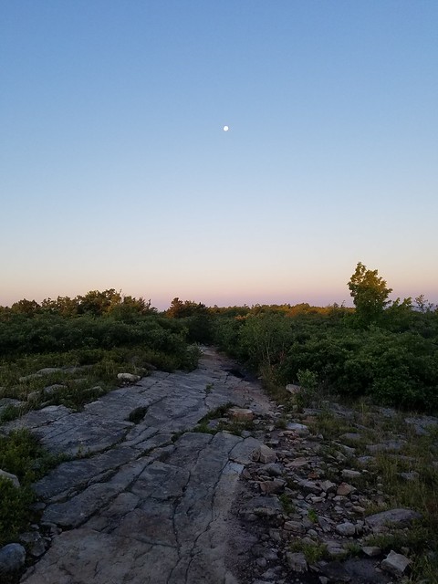
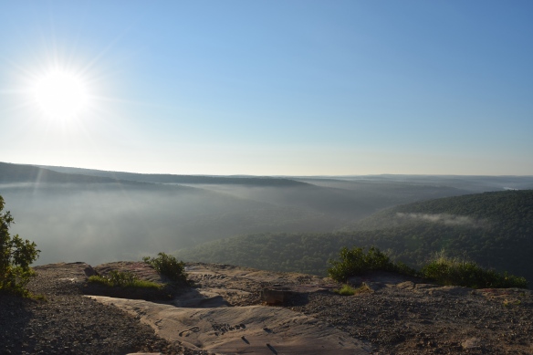
I mistakenly took a trail to the right, instead of the official trail to the left, and climbed through the forest until I reached a ridge with stunted oak and bedrock slabs. The moon rose overhead, beginning its descent to the west. I reached the barrens and enjoyed views just as the sun crested the horizon. I found a trail that descended to the right and my phone confirmed it was the proper route. I descended and barely circumvented a massive mud puddle, and soon reached a stunning vista from a towering cliff above Roaring Brook. According to Google Earth, this place is called High Rocks. Layers of mist and slow moving clouds hung in the valleys below. The tops of the plateaus rose just above the mist. The sunrise cast the cliff in hues of amber and orange. I could see for about 20 miles across the Pocono plateau. Off to my right was I-84, a ribbon of concrete through the green forests. Far below was the silver thread of Roaring Brook. I could see some rock climbing bolts in the cliff. As the sun rose, the mist dissipated and the clouds slowly moved across the ridge. I could feel the heat of the day. I followed a trail along the crest of the cliff with non-stop views. This trail descended to an old vista, now grown over, and I followed another trail that looped back to High Rocks. I did more exploration of the trail along the cliff to the east, to see more vistas. I was amazed by the beauty of this place.
https://www.flickr.com/photos/49239558@N04/28857898580/in/album-72157672785737135/
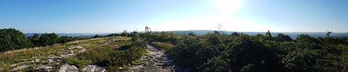
I returned to the huge mud puddle and climbed to the ridge. I hiked northeast along the ridge and it was spectacular with incredible views off both sides of the ridge. In places, there were almost 360 degree views. Meadows and dwarf oak trees surrounded the trail. These views easily rivaled those at the nearby Eales Preserve. The trail began to descend and I turned around retracing my steps.

I plan to return to follow the “official” trail to see remnants of the gravity railroad grades and stone bridges.
Another place of great beauty within miles of Scranton.
More photos:
***********************************
This hike is pretty easy to navigate. Keep in mind I did not follow the “official” hiking route, which I’ll attempt to describe below. Coordinates are from Google maps.
- I parked here: 41.414494, -75.598228. This is at the gate. Parking is very limited here, space for only two cars. Otherwise park at the lot for the trail around the reservoir, located here: 41.416882, -75.599199. Hike the loop counterclockwise (right), below the dam, and to Tigue St.
- Follow gated Tigue Street to its end, at a meadow with views and wildflowers. 41.410386, -75.596232.
- In the meadow, the trail bends left here: 41.409262, -75.592827
- Enter the woods with a preserve and trail sign.
- Climb through the woods along an old grade, passing other intersecting trails.
- Hike to the ridge at 41.410813, -75.573643.
- Turn right and hike along the ridge with excellent, non-stop views.
- Leave the ridgetop trail to the left. 41.406457, -75.576815.
- Descend and hike around a large mud puddle.
- Turn right at the next trail intersection, more views. 41.405449, -75.575928.
- The High Rocks cliff and vista are located here: 41.404856, -75.575889.
- The views are spectacular, rising 600 vertical feet over Roaring Brook. These are huge cliffs, so be careful at the edge. I-84 can be seen. Views are for about 20 miles.
- Retrace your steps.
- This appears to be a part of the Lost Trails, an ATV trail system. Hiking is permitted based upon the signs I saw. I do not know the extent of the Gravity RR Preserve’s boundary. Regardless, this is private land, so treat it with respect. Traffic can be heard from I-84. The views are best at sunrise or sunset. Enjoy.
https://www.flickr.com/photos/49239558@N04/28526447583/in/album-72157672785737135/

How long is this hike, mileage wise?
About two miles, one way.
Thanks so much for detailing the hike as well as you did. Two of us did this hike yesterday (ended up being about 6.2 miles round trip). Great views, totally worth every step. We also were able to do a little drone flying at the top.
Thanks for the mileage, I didn’t have a GPS. Glad you enjoyed the hike, it is a great place.
Do you know where I can obtain an official map of the area? The beauty is alluring. I would love to hike it.
I do not know of a map. The trails can be seen from Google maps, satellite view.
Outstanding photography. I grew up in Dunmore, PA and spent countless hours all over this area. However, it has never looked more beautiful than it does in these photos.
Thanks, there is surprising beauty around Scranton.
july 9 2017 jeff i m lee from sullivan falls-looking at a dcnr map of susquehannock state forest and saw a stream called waterfalls hollow.its between germania and oleana east of rt 144.[77 41 long,41 36 lat approx] seems to be a small tributary of little indian creek.probably about 1.5 mi. bushwack from rt 144.have you heard of this or been there?small stream-so water would have to be very high.sounds great if real.not on delormer map.not far from susquehannock trail system-i know you have hiked that .let me know if you have info.Lee A.
Lee, never hiked that, but told there are no sizeable waterfalls, just cascades. Hope all is well.
want to check this out but just an fyi, I saw a comment on a youtube video stating hikers are not allowed on the lost trails property. it appared to be from someone who works there… I wrote to the lackawanna river society who is supposed to own the preserve in hopes of finding out the real story.