

New Pinchot Trail re-route along Choke Creek
The south loop of the Pinchot Trail has been re-routed in four places. The trail has been removed from all roads and the scenic beauty has been greatly improved. The south loop is now one of the most scenic, easy backpacking trails in the mid-atlantic. It features incredibly diverse forests of hemlock, pine, spruce, laurel, hardwoods, and rhododendrons. There are waterfalls and cascades, beautiful streams, beaver dams, and views of vast meadows and wetlands. The terrain is forgiving, although rocky in places.
SR 2016/Tannery Rd. Re-route

The first re-route is where Tannery Road meets Bear Lake Road/SR 2016. Hiking the loop clockwise (south) from the parking area, the new route passes through spruce forests, fern meadows, blueberry bushes, a small stream, rhododendron, and mountain laurel before turning left on the pre-existing route. If hiking counterclockwise, this turn can be easy to miss. The old trail route along Tannery Road has been abandoned and the blazes have been painted brown.
Phelps Rd. Re-route

The second re-route avoids a roadwalk on Phelps Road. Hiking clockwise, cross Phelps Road and enter the woods, hiking along rhododendrons, laurel, and passing near a bubbling sand spring. Cross a scenic, small stream with more rhododendrons and then reach the pre-existing trail route. The old route has been abandoned and the blazes painted brown.
Tannery Rd. Re-route

The third re-route is the second longest and avoids the prior tedious roadwalk on Tannery Road. Hiking clockwise (west) the new route leaves the pre-existing route of the trail and meanders through beautiful forests of pine, hemlock, spruce, laurel, and rhododendron. These forests are very diverse, stay green even in winter, and have some old growth trees. The new route turns into a hardwood forest with blueberry bushes and ferns. Turn right and cross a gated dirt road. The new route continues under beech trees, meanders through ferns with occasional spruce, passes an open area with rocks, and then veers left along a deer fence. Leave the deer fence and enter another beautiful spruce and hemlock forest with a stream. Cross another small stream and reach a fine view of a large wetland. The new route then follows the state forest boundary to the pre-existing route of the trail. The old route along Tannery Road has been abandoned. The old Pinchot Trail south of the Choke Creek Nature Trail parking area along Tannery Road is now blazed yellow to allow for a dayhiking loop.
Choke Creek Re-route
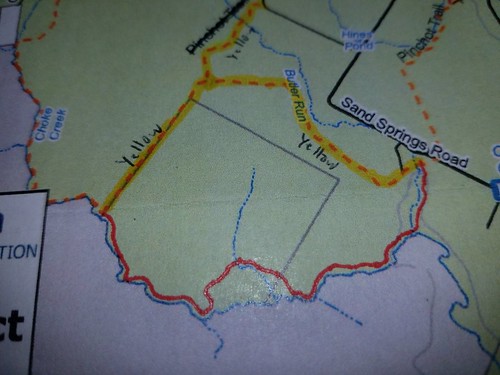
The fourth re-route along Choke Creek is the longest, most scenic, and the wildest. Hiking clockwise (west) from Butler Run, the new route goes through a beautiful hemlock forest, meadow along Butler Run, and reaches a jeep road at a log bridge. Cross the bridge and turn left on a well-established trail to gorgeous Choke Creek Falls. The new route now goes upstream along beautiful Choke Creek, going through forests of spruce, pine, hemlock, and hardwoods. There are blueberries bushes and meadows. Enjoy some cascades and slides along Choke Creek. Hike above a beaver dam and swamp and then reach a superb view of a large meadow with Choke Creek meandering through. Leave Choke Creek and cross rocky areas with a diverse forest. The new route then follows a scenic, small stream under a grove of hemlocks. Return to the hardwoods with some rocky areas and fern meadows. Descend back to Choke Creek with beautiful meadows and meandering streams. Continue up along the creek with beautiful scenery, diverse forests, and cascades. A spruce grove with a cascade is a particularly beautiful spot. Huge pine trees rise over the trail. Reach another cascade and slide with a pool. The new route passes another fine view of a wetland under hemlocks, a beautiful spot. Continue up along the creek with fine scenery. The new route moves away from Choke Creek, goes through a spruce forest, and reaches the pre-existing route of the trail. This re-route is very beautiful, well-blazed, and large brush has been removed, but low brush remains in places. Over time a tread will be established as more people hike it. The old route of the Pinchot Trail is blazed yellow, creating an excellent dayhiking loop.
Enjoy these new re-routes!
Photos of maps and scenery of the re-routes.


I just hiked this in November, not knowing that the trail had been relocated. It adds a lot to the trail interest, especially where it passes Choke Creek Falls. Anyone know when it was done, and who by?
The reroutes were complete at the end of September. Pinchot State Forest personnel and myself scouted. The state forest, Keystone Trails Association, and myself cleared the new trails. The Choke Creek reroute still needs some clearing, but overall people seem to enjoy the new reroutes. Thanks for hiking the trail.
thank you for doing that, I backpacked it September and it was very nice, there was actually a gentleman out reblazing it and he told us the new route. Will there be a new map of this online that we can print or get from the DCNR? I only see the older version
I’m glad you enjoyed it, I think it’s a huge improvement to the trail. I’m not sure when DCNR will have a new map.
Just wanted to say the Choke Creek re-route is spectacular, thank you for your contribution to all the hard work. I hike a loop one afternoon this Labor Day weekend, walking the Butler Run Trail down to Choke Creek and back on the new section in the opposite way that you describe above. Such a beautiful addition to the trail system. Hopefully DCNR will update the trail map soon.
Thanks, glad you liked it. DCNR will be updating the maps soon.
Thinking about doing a solo beginners backpack trip in spring ’19 on the south loop now i see a re-route and sense it might be easier then the north loop(that was my original option) , would it be considered easier terrain wise and easier to follow the blazes then the north loop?, and what about parking for the south loop?, Thanks! as a member of the allentown hiking club , i understand all the hard work that goes into trail maintenance!,
South loop is easier, some areas are brushy and beavers have flooded part of the trail along Choke Creek. I think the south loop is more scenic and diverse. It also has better camping. You can park where Tannery Rd. meets Bear Lake Rd. Have fun.