
Pennsylvania has the most extensive system of backpacking trails in the east, and the most loops. These loops are 1.5 to 3 days long and are up to 50 miles in length. Which are the best? Here’s your list!
Eastern Pennsylvania
Pinchot Trail-South Loop. The Pinchot Trail nearly bisects itself, creating a north and south loop. The south loop is particularly scenic with diverse forests, habitats, streams, and Choke Creek Falls. The section along Choke Creek is beautiful with great camping. With mild terrain, this is a great trail for beginning backpackers. About 14 miles.
Loyalsock/Link Loop. A classic loop that should be on every backpacker’s list. Many hikers begin from Worlds End State Park and hike the Loyalsock and Link Trails to form a loop. There are views, waterfalls, hemlock forests, Sones Pond, and the beautiful Loyalsock Creek. This loop also has great camping. It has moderate to challenging terrain. About 17 miles. You can also start at the Mead Road parking area and create a lollipop loop, this would include Dutchmans Falls and the famous Haystack Rapids. Map.
Central Pennsylvania
Old Loggers Path. This perfect loop is loved by backpackers. It has moderate terrain with views, two shelters, waterfalls, big rocks, creeks, fine camping, and good isolation. It’s not too hard, or too easy, it’s just right. Rock Run is gorgeous and a highlight, as are the views from Sullivan Mountain and Sharp Top. There is no bridge across Pleasant Stream, which is dangerous in high water but fine to cross most of the year. About 28 miles. Map.
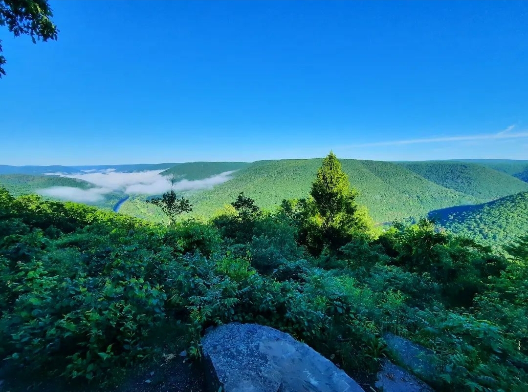
Black Forest Trail. One of the state’s finest trails, the BFT is known for its challenging terrain and incredible views. Also enjoy meadows, gorges, some waterfalls, rock outcrops, and streamside hiking. There is a good diversity of forest types. The trail dives in and out of gorges, but all the views make it worth it. This is a tough, rewarding trail. It is a must-do. About 42 miles. Another great thing about the BFT is all its side and connector trails, allowing for a variety of loop options. Map.
Slate Run Loop. An excellent loop for those who don’t want to tackle the entire Black Forest Trail. This loop circles the Slate Run Gorge, it is beautiful. Enjoy great views, a few waterfalls, superb camping, and a short side hike to a stunning swimming hole. Terrain is challenging. About 14 miles.
Blackwell/Slate Run Loop (Big Four in the Gorge). An easier alternative to the Black Forest Trail in the Pine Creek Gorge. Follow a network of trails, including the four state forest hiking trails: Black Forest, West Rim, Mid State, and Golden Eagle. This loop has great views and several waterfalls or large cascades. Enjoy scenic creeks and gorges. It’s challenging. About 42 miles.
Tiadaghton Trail/Mid State Trail Loop. Combine the Tiadaghton and Mid State Trails to create a spicy, challenging loop with great views, cascades, and rock formations. A shorter alternative to the Black Forest Trail. This loop is tough. Camping is a bit limited on this loop. About 23 miles. Map.
West Branch/East Fork Loop. Wow, the best loop with moderate terrain that you never knew existed. I loved this loop. The loop for you if you love meadows, beaver dams, ponds, and lodges. So many meadows. Good isolation, streamside hiking, and even a sublime shelter. About 22 miles.
West Branch/Susquehannock Trail Loop. This is the loop to the north of the West Branch/East Fork Loop. While this one is not quite as scenic as the other, it is still worth doing. Enjoy the meadows on West Branch Trail, and the forested gorges and sublime forest walk on the Susquehannock. There is one fine shelter, a dynamite shelter repurposed as a hut, and a view. Some good camping too. Terrain is moderate. About 25 miles.
Allegheny Front Trail. Another gem backpackers love with a great diversity of scenery. Enjoy views, meadows, rhododendron tunnels and great streamside hiking. The cross connector (Shingle Mill and Moss Hanne Trails) has some of the most extensive boardwalks in the state. The cross connector creates two loops on the AFT, an east loop and west loop. Most consider the east to be more scenic, but the west is great too. Terrain is primarily moderate with some challenging sections. Entire loop is 43 miles. Map.
Chuck Keiper Trail-West Loop. The CKT had fallen on hard times, but with help from the Keystone Trails Association and other volunteers, the trail is getting some maintenance love and is coming back to life. The west loop is regarded as more scenic and had been the better maintained. It’s a tough trail with good isolation. Enjoy creek side hiking, a few waterfalls, great camping, beautiful creeks, gorges, and different forest types. About 33 miles. Map.
Quehanna Trail/East Cross Connector Loop. This big loop is about 50 miles and features an array of scenery. Enjoy meadows, cascades, giant boulders, glens, views, creeks, good camping, and isolation. Not to mention elk. Moderate to challenging. Off the ECC, consider including Teaberry, Lincoln Loop, Bridge, and Crawford Vista trails for an even more scenic trek. Map.
Quehanna Wild Area. Wow, what a place. This is a loop making wonderland with a variety of routes to choose from. This the premier place for a choose-your-own-adventure-loop in the state. What are the most scenic trails you’d want to include? Take a look at the following trails: Teaberry, Lincoln Loop, Marion Brooks Loop, Bridge, Crawford Vista, Ralph Seeley, Panther Run, Kunes Camp, Wykoff, Big Spring Draft, Sevinsky, Gore Draft, Foley, Sanders, Red Run. Map.
Here are some loops I’ve done in Quehanna Wild Area:
Western Pennsylvania
Morrison Trail. A favorite in the Allegheny National Forest, enjoy giant rocks, cascades, great camping, views of the Allegheny Reservoir, fern glades, and mountain laurel blooms. Black Bear Trail is a new side route, it is nice but not a must-do. The loop’s cross connector is particularly beautiful and Morrison Run is gorgeous as well. There is a fee to use the campground along the reservoir, which is popular with boaters in warm weather. Terrain is moderate. About 11 miles. Be sure to see Rimrock Overlook, which is nearby.
Tracy Ridge Hiking Trail System. This is a network of trails near the Allegheny Reservoir, you can easily make a loop exceeding twenty miles. Most people do the 10 mile loop of the Tracy Ridge, Johnnycake, and North Country Trails. However, the North Country Trail from Handsome Lake to Nelse Run is also beautiful, as is the trail along the reservoir to Polly’s Run. Trails can be muddy. The highlight is camping along the reservoir. Terrain is moderate to challenging. Map.
Minister Creek. The most popular trail in the Allegheny National Forest, enjoy giant rock outcrops, cliffs, chasms, and other formations. Be sure to include the gorgeous South Loop. There is one view and great camping. Terrain is moderate. About 7 miles. Map.
Gerard Hiking Trail. This 36 mile loop encircles Oil Creek State Park, featuring waterfalls, some views, and shelters. It winds in and out of hollows with small streams. It passes remnants of the oil industry that existed here, home to the world’s first commercial oil well. This trail is surprisingly rugged and there are cross connectors to shorten the loop. There is a fee to stay at the shelters. Map.
Quebec Run Wild Area. A gem in southwest Pennsylvania, Quebec Run has moderate terrain with scenic streams, great camping, and good isolation. Hike through tunnels of rhododendron and laurel, or open hardwood forests. You can make loops up to 10 miles. Mill Run, Rankin, and Tebolt Trails are among the most scenic. Map.

