Hike to Pine Island Ledge Vista and Waterfalls-Pine Creek Gorge (PA Grand Canyon)

Pine Island Ledge Vista

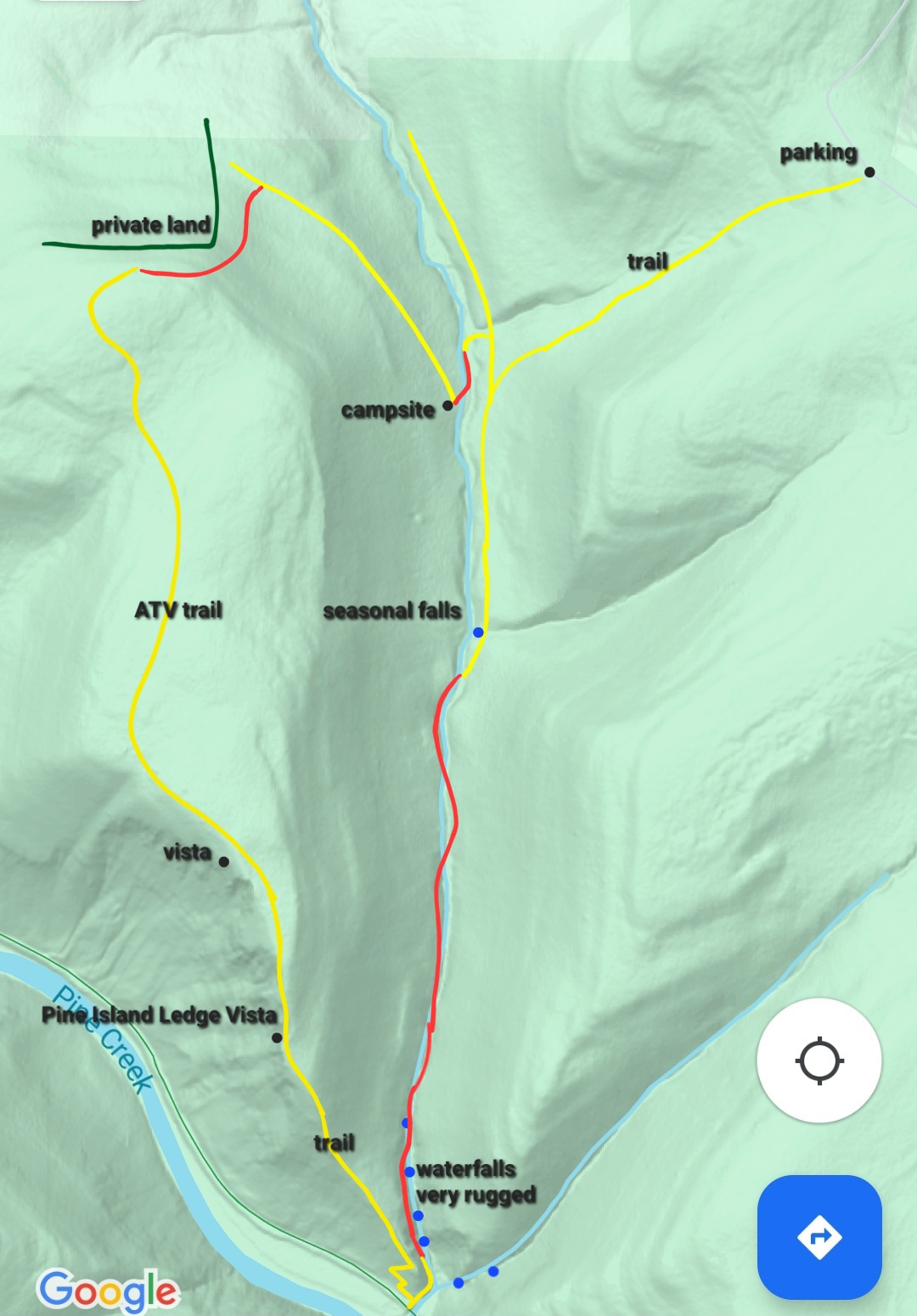
Length: Approx. 8 miles

Difficulty: Very difficult and challenging.

Trail conditions: Route follows unmarked and unblazed trails, old forest roads or grades, and off trail hiking. It is a steep climb or descent to/from Pine Island Ledge. The bottom section of Pine Island Run requires scrambling along waterfalls and traversing a landslide. It is the most challenging part and potentially dangerous. Do not attempt in high water.

Highlights: Incredible views, cliffs, rock outcrops, glens, many waterfalls and cascades.

Parking: 41.631387, -77.395402. Drive in from the north. There is no bridge where Claymine Road crosses Stony Fork.

Peregrine falcons: They nest at Pine Island Ledge. I was not aware they were nesting when I visited. Consider hiking elsewhere until their nesting season is over.

Rattlesnakes: Can be found at the vistas, and along the hike.

Cliffs: This hike goes near massive cliffs. Be careful. Any fall would be fatal.

Other navigation aids: Look at MyHikes for Pine Island Run and Ledge. You might want to hike them separate to avoid the lower section of Pine Island Run. Also, a prior post to the ledge.

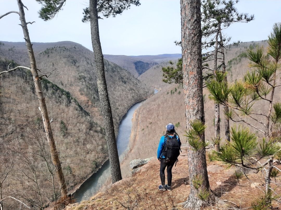
Description: Pine Island Ledge is widely considered the most beautiful view in the Pine Creek Gorge, if not Pennsylvania. I think it is one of the most beautiful canyon or gorge views in the eastern U.S. Here, the canyon is so narrow and Pine Creek flows hundreds of feet below. The ledge has become an increasingly popular destination in the Tioga State Forest.

This is a very challenging hike, only experienced hikers should attempt. It is one of the most beautiful, and difficult, hikes in the Pine Creek Gorge. Most hikers to Pine Island use the rail trail, but this way is long and taxing. The hike from Claymine Road is much more scenic and challenging.

Hiking the loop clockwise or counterclockwise has its benefits. Clockwise requires a difficult scramble down Pine Island Run and a steep climb up to Pine Island Ledge. Counterclockwise is the opposite. It may be best to scramble up the lower gorge of Pine Island Run, which I consider the most challenging part. You can always skip this part and just go to the view.

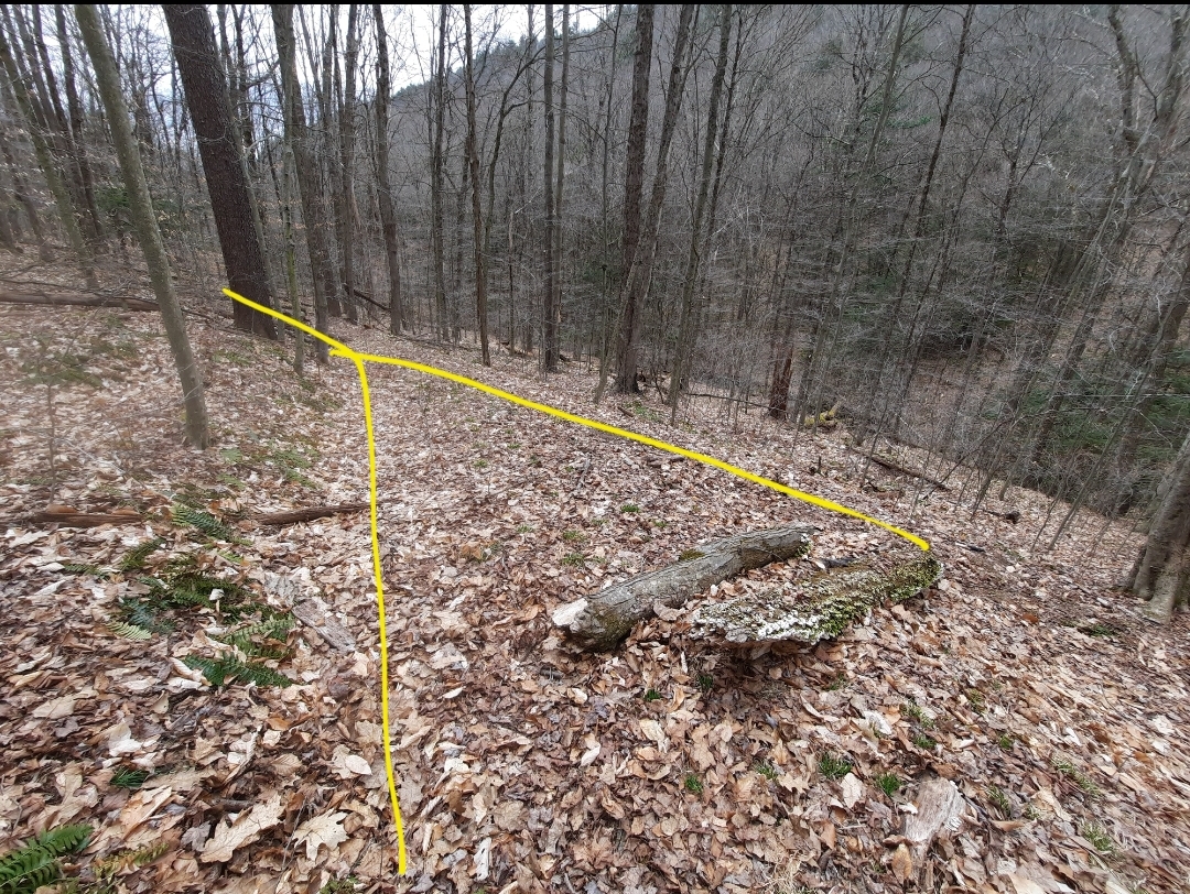
From the parking area, follow an obvious trail through laurel down to Pine Island Run. Reach an intersection (see picture below). Go left to hike clockwise, right is counterclockwise. We hiked clockwise.

The hike along Pine Island Run is very beautiful with many cascades and slides. You will have to hike off trail much of the way and cross where you need to. The bottom of this gorge is very beautiful but challenging. It is best to stay on the west side of the creek. Be careful crossing a landslide. Rocks and cliffs tower above. Never attempt this hike in high water as the lower part of the gorge becomes too dangerous.

An unmarked trail makes the steep climb to the view. The view is simply incredible, framed by pine trees. An obvious trail continues north from the view, it becomes an old atv trail. There is one more view. There are beautiful pine and hemlock forests. The trail reaches private property, here go off trail to the east, roughly following the state forest boundary markers. Descend to an old grade This grade will take you to a campsite. Cross the creek and complete the loop.

You should have navigational aids or apps to hike this trail, especially the off trail part at the north end of the loop. The rest is fairly easy to navigate.

Parking on Claymine Road. Trail begins behind white sign.
This is where the trail from the parking area meets the loop. Left is down Pine Island Run, clockwise. Right is counterclockwise.
Red is off trail. Yellow are unmarked trails or old logging grades, some can be faint. Blue dots are waterfalls or cascades. This is not a gps track, accuracy not guaranteed, it is for general directional purposes only. Hike at your own risk. This is a very difficult hike with potentially dangerous sections.

Hike to Gamble Run Vista-Mid State Trail

Gamble Run Vista

Length: About 1 mile, one way.

Difficulty: Easy hike

Blazes: Orange. Short side trail to vista is unblazed.

Terrain: level and rolling to the vista

Parking: small lot is at about 41.236678, -77.374679. Old Coudersport Pike was in good shape.

Highlights: Vista, ferns, mountain laurel

Issues: We couldn’t find the second vista lower on the ridge.

Description: This is a short and easy hike on the Mid State Trail to a fine vista overlooking the deep gorge of Gamble Run. From the parking area, the trail travels through fern meadows and into mountain laurel thickets. The trail was well blazed and in good shape. The terrain was level and rolling with a gradual incline.

After about a mile, look for a cairn and a short unblazed trail on the left that goes down to the vista. The view is very nice as it overlooks and the plateau and gorge. Maps show a second view lower on the ridge. We hiked down to see it, but did not locate it. Maybe we didn’t hike far enough, or it is overgrown. We retraced our steps back to the car. The descent looking for the second vista was steep in places.

If you’re looking for a short, easy hike to a fine view, this is the hike for you. If you want a harder hike that’s nearby, hike Gamble Run to the view over Schultz Fork.

Mid State Trail

More photos:

Hike the Eiger/Log Slide Loop-Pine Creek Gorge

Bull Run Vista, Pine Creek Gorge, Tiadaghton State Forest

Length: Approx. 3.5 miles

Parking: At the Tiadaghton State Forest district headquarters, 41.314481, -77.384649. Do not park along Lower Pine Bottom Road as there is no space.

Highlights: Beautiful view, old quarries, ledges, mountain laurel, historic log slide.

Issues: The climb is steep in sections.

Level of Challenge: Moderate to difficult

Trail conditions: Trails were in good condition.

Blazes: Lower Pine Trail is red, remainder of trails are yellow.

Description: The Pine Creek Gorge in the Tiadaghton State Forest is home to many hiking trails and this is one that should be on your list. Park at the forest headquarters which has its own views and wildflower meadows. If the building is open, be sure to check it out to see the displays and a balcony with a green roof and more views.

The red Lower Pine Trail begins at the end of the parking area and descends in a pine forest. Reach Lower Pine Bottom Run with a small cascade and hike the edge of the giant arched concrete culvert. Reach Lower Pine Bottom Road and turn right. Hike up the road a short distance. Turn left at a trail sign, which calls the Eiger Trail the “Quadfather”, you’ll soon see why. Hike behind a cabin and reach the beginning of the loop, continue on the Eiger Trail as it follows an old grade through laurel. The grade steepens as it climbs the flank of the mountain. Begin to pass old quarries and ledges.

The trail eases as it follows the grade along the steep slope of the mountain. I liked this part as the trail offered such forgiving tread across steep terrain. The forested slopes just fall away. Reach a large quarry and more ledges. The ledges continue before the trail begins a series of well built switchbacks up through the laurel.

Finally, the trail levels off at the top and you soon reach Bull Run Vista, an impressive view of the Pine Creek Gorge. The vast plateau is incised with many gorges and glens. Pine Creek is about 1,200 feet below.

Now begin the Log Slide Trail through mountain laurel. This trail would be beautiful in late June when the laurel blooms. The trail then begins its descent on an old log slide, which is somewhat gradual. Hike through groves of hemlocks with moss. Pass an old stone retaining wall for the slide. Reach the end of the loop and retrace your steps. The Log Slide Trail is easier than Eiger, but both are worth hiking.

More photos:

Hike to Gamble Run Falls and Vista-Tiadaghton State Forest

Gamble Run Falls

Length: Approx. 6-7 miles in total to the falls and vista.

Blazes: Mid State Trail is orange, Gamble Run Trail is red.

Parking: Small lot at 41.242016, -77.334424.

Trail conditions: Good. Trails are well blazed and easy to follow.

Highlights: Cascades, small falls, pools, streamside hiking, hemlocks, vista, beautiful gorges.

Issues: Hike up to the vista is steep and rugged.

Level of challenge: Easy to difficult

Description: I really enjoyed this hike and look forward to returning. It is yet another gem in the Pine Creek Gorge region. This is an out and back hike to both the falls and vista. Part of this hike follows the Mid State Trail (MST) the longest trail in the state and a part of the Great Eastern Trail, which goes from Alabama to New York.

From the parking area, hike up and around the meadow with some nice views on the Gamble Run Trail. Expect wildflowers in summer. This meadow really reminded me of the Appalachian Trail in Virginia during my thruhike this year. Drop down and follow an old grade. At first it is well above the creek, but it gradually comes closer. Along the way, the MST joins. Gamble Run nears the trail and it is adorned with cascades and pools of clear water. There is moss, ferns and hemlocks. The cascading water accompanies the trail as you gradually hike up.

Reach Schultz Fork where the MST turns right and begins the climb. Here, Gamble Run has a beautiful slide and deep pool. This is a gorgeous spot. Continue on the red Gamble Run Trail into the scenic gorge. The cascades, ferns, and moss provide the scenery. Up ahead you’ll notice a large ledge with a deep pool; the creek slides through a narrow chasm. This is Gamble Run Falls. Not more than ten feet tall, it is quite beautiful as the water has sculpted the bedrock. While the Gamble Run Trail continues, turn around here and return to the MST at Schultz Fork.

Now begins the climb into this rugged gorge. Schultz Fork is seasonal, but has a variety of beautiful cascades and small waterfalls when flowing. Seeing and hearing the water eases the climb. The trail steepens and moves from the creek. Reach the heart of the rugged gorge where two branches meet and a cliff looms on the other side. The MST turns left and makes a final climb; if the trees are bare, the rugged gorge spreads before you.

The MST makes a sharp right turn. Here, look for faded blue blazes on the left. Follow this trail a few hundred feet through the laurel and reach beautiful Gamble Run Vista (or Schultz Fork Vista) from a ledge. Overlook the deep gorges and tiers of ridges with no signs of development or traffic. It is a glorious window into the wilderness and well worth the climb to see a view most hikers probably miss. This is an ideal sunrise vista. Hidden gems like this vista make hiking so rewarding and underscore the beauty of the MST. From here, retrace your steps to the parking area.

Cascades, falls, pools, moss, ferns, hemlocks, meadows, and a wilderness vista, what more do you want on a hike?

This map is for general directional purposes only, it is not a GPS track.

More photos:

Hike the Ott Fork Trail-Tiadaghton State Forest

Waterfall on Ott Fork

Length: 3 miles, one way

Blazes: None, but the trail is well established and easy to follow

Parking: Pull off parking is at 41.318569, -77.413760

Highlights: Waterfall, cascades, hemlock forests, streamside hiking

Issues: Several stream crossings

Level of challenge: Easy

Description: The Pine Creek Gorge is a hiking wonderland with a vast array of trails. It is also a trail running destination. The hike along Ott Fork is beautiful as it follows a creek with its cascades and hemlock forests. This trail is also along the Eastern States 100, one of the premier trail races in the country.

From the parking area, just follow the old grade as it enters the gorge of Ott Fork. You will soon see some waterfalls and cascades, no more than ten feet tall, but still very scenic. These are the tallest falls on the trail. Continue upstream with some stream crossings and an old bridge abutment. Cascades dot Ott Fork. Mountain laurel and some rhododendron adorn the forest.

As you hike, hemlocks become more common with moss. Some of the trees are somewhat large. Ott Fork babbles off to the right. Pass a juncture with the Pine Hollow Trail. Continue along Ott Fork until the trail ends at a dirt road. Retrace your steps.

This is an easy and enjoyable hike that feels isolated. Ott Fork is a gem worth visiting. While in the area, visit Mountain Top Provisions for a meal.

This map is for general directional purposes only and is not a GPS track.

Hike to Chimney Rock-Tioga State Forest

This hike leads to one of the finest views of Pine Creek. There are two ways to begin. You can begin along PA 414 and hike up the Bull Run Trail; this way is longer and more challenging, but makes the view more rewarding. The other way is to drive to the end of Old Mountain Road and park. This way is much shorter and easier, however, the road can be muddy and rutted, so a vehicle with clearance is recommended.

I began from PA 414 and hiked up the yellow Bull Run Trail. This was a scenic trail, and the steady climb wasn’t really all that bad. Bull Run is a small creek and can dry up in the summer. When flowing, it has many small waterfalls and cascades, making for great scenery. Moss, ferns, and hemlocks adorn the trail up Bull Run. As I reached the top, there were many saplings; this was an area that was burned in a fire years ago. The trail leveled off and went through the saplings and some small meadows. I then reached Old Mountain Road.

I turned left and followed the sign for Chimney Rock Trail, also blazed yellow. The trail went through groves of pine and along some meadows. This area was also burned years ago. The trail moved towards the edge of the plateau with some nice views through the openings in the trees; in winter the views would be extensive with the bare trees.

The hiking was level along the edge of the plateau and then a gradual descent began. I hiked past ledges and the descent steepened with large rock outcrops. The woods were open with oak trees. The final stretch to the view was quite steep, but manageable.

Chimney Rock Overlook is impressive with its views of Pine Creek, and the ridges, peaks, and plateaus that surround it. The terrain is diverse and beautiful. Hundreds of feet below is the rail trail and a bridge across the creek. There is a flag at the view. This view is great for sunrises.

There is another view, a short distance off trail, at the point of the plateau. It offers a great view looking down Pine Creek.

From here, retrace your steps.

Parking at PA 414 is at about 41.534728, -77.426813. Parking on Old Mountain Road is at 41.542423, -77.437155. From PA 414, this hike is about three miles, one way.

Scroll through the photos.

Stone Cutter and Tiadaghton Trail Loop-Tiadaghton State Forest

This is a great dayhike loop in the Pine Creek Gorge, offering views of the creek, rail trail, two fine views, rock outcrops and a small stream.  It is about five miles long.  Parking is at two places in Ramsey, and both have limited parking for about four or five cars.  

From the parking area, follow the rail trail to the left or south and cross Pine Creek on an old steel bridge.  Enjoy views of the creek and surrounding canyon.  Continue on the rail trail and look for a discreet trail juncture to the right.  Take it and follow the yellow blazes.  Continue straight up the hill on the Tiadaghton Trail.  Reach an old quarry site, and the climb becomes steeper; avoid the trails that join from the left.  The climb remains steep as you ascend the ridge, passing some rock outcrops.  Reach the ridge with more unique rock outcrops and ledges.  Another climb brings you to a stunning 180 degree view of the Pine Creek gorge from rock outcrops.  Enjoy the superb scenery.

Continue on the yellow Tiadaghton Trail as it climbs up the ridge; however, this climb is much more gradual.  Moss and pine trees often adorn the trail.  Descend gradually along the narrow ridge.  In winter, expect extensive views through the bare trees. The yellow Turkey Vulture Trail joins from the right.   Reach a second view looking down the gorge, another beautiful sight.  Turn left onto a  trail and leave the Tiadaghton Trail.  Descend to the Stone Cutter Trail which follows an old forest road above Bonnell Run, a small, babbling creek with some small cascades.  Follow the Stone Cutter Trail down, enjoying views of the creek and the valley.  The trail does not get very close to Bonnell Run.  

Reach the orange Mid State Trail, and you can go either way.  Left will take you along an old grade that will descend to the rail trail.  Right, or straight, will take you down Bonnell Run and you can connect to the rail trail at the bottom; just be sure you do not continue following the Mid State Trail up the mountain.

Hike the rail trail to the left with many wildflowers.  Pass a camping area and some shelters.  Cross the bridge over Pine Creek and retrace your steps.  

Parking in Ramsey is at 41.284498, -77.324630 or 41.284322, -77.321053.  Again, parking is limited.  

Hike the Golden Eagle Trail and Dragon’s Back Trail Loop-Tiadaghton State Forest

I met some friends from college to hike this excellent loop, totaling 10.3 miles.  It follows the classic Golden Eagle Trail and the fairly new Dragon’s Back Trail featuring several views, rock outcrops, and cascades.  It is considered one of the finest dayhikes in the state.  I recommend adding the Dragon’s Back Trail as I feel it is more scenic than the Golden Eagle Trail along Bonnell Run, which is still very scenic with a gorge of open hardwood forests.

From the parking area, we crossed PA 414 and began on the GET as it climbed up a gorge.  We turned right to begin the loop as falls tumbled below us to the left.  We made the long climb up to the ridge, which steepened as we neared the top.  It was getting warm and the sunlight filtered through the forest.  We reached the ridge and enjoyed the breeze as we descended passing a fine view to the left that looked up Wolf Run and then shortly thereafter, the classic view from Raven’s Horn and its unique rock outcrop.  The view was stunning as we looked into the Pine Creek Gorge as green mountains surrounded us.

Our descent continued along the ridge, passing more unique rock outcrops.  The trail then followed Wolf Run, which was flowing low, but has many cascades and small falls in a deep gorge.  We passed outcrops of flagstone, with sheaths of rock that looked stacked.  The trail along the creek was beautiful, and we crossed it several times.  When flowing well, Wolf Run is truly beautiful.  As we neared the top, there was a an old growth forest of giant pine and hemlock.  We reached our first view and then hiked through the laurel to an old forest road, which we took to Beulahland Vista, a gorgeous view looking over the fields and mountains of northern Pennsylvania.  

We continued on the grassy road, passing another excellent view, Bonnell Run Vista.  The GET then turned left, but we continued straight on the grassy forest road to hike the Dragon’s Back Trail.  We soon entered the woods and followed the yellow blazes along the forested ridgeline that narrowed with steep slopes on both sides.   We enjoyed another view, Webber’s Vista, looking down on Slate Run. We made another short climb, and then descended on a series of grades that switchbacked down to PA  414.

We crossed the road, walked down to the rail trail, and turned left on it.  The rail trail had great views of Pine Creek, wildflowers, and even an old cemetery.  It was a great way to end the hike.   We reached our cars and went to Slate Run for a meal.  

Pine Creek Gorge has dozens of excellent hiking trails for any ability.  However, hiking here generally means climbing.  The views make it more than worth it.  

Parking is at  41.439008, -77.511436.

Scroll through the photos.


Hike to Hemlock Mountain-Tiadaghton State Forest

Hemlock Mountain is one of the highlights along the rugged 42 mile Black Forest Trail, a popular backpacking trail loop.  While Hemlock Mountain is known for its steep climb if you follow the Black Forest Trail, there is an easy way to get to the mountain and enjoy its superb views of the Pine Creek Gorge.  This hike is a little over 2 miles, one way.

Park at the small parking area on Big Trail Road, located at about 41.454056, -77.564225. There is space for about three cars.  Follow the yellow blazed Old Cutoff Trail as it descends on some long switchbacks and then levels off along a forested ridge with hardwoods and laurel.  After another descent, reach the orange blazed Black Forest Trail, on which you will go straight, or left.  Follow the rolling ridge.  The trail then begins a steeper climb up Hemlock Mountain.  Enjoy one view looking toward the plateau with two windows through the trees.  Continue climbing under pine trees as the trail begins to level.

Reach a dry campsite and an excellent view looking south down the gorge.  This is a famous view of the gorge and it is stunning, particularly in the morning when it is often above the clouds and mist.  The size and scope of the canyon are breathtaking, as it is surrounded with towering, vast plateaus with furrows of ridges.  Continue on the orange Black Forest Trail as it descends to another view of the gorge, this one looks north.  If you continue on the Black Forest Trail, you will reach a long, steep descent into Naval Run, so you will want to retrace your steps.  

Fork Hill-Stone Quarry Run Loop (Tioga State Forest)

This is another enjoyable hike you can do from the village of Blackwell, which is surrounded by great hiking whether it be Gillespie Point, Bohen Run and Jerry Run Falls, or the West Rim Trail.  This loop follows a recent re-route of the Mid State Trail up Fork Hill, offering a nice view from Johnson Cliff.  You can extend the hike with a spur to another view over the PA Grand Canyon.

From the parking area in Blackwell, walk up the road and turn left onto the Pine Creek Trail, a rail trail.  Then turn right at an impressive wooden staircase on the Mid State Trail (MST) which is blazed orange. This is also the Great Eastern Trail, stretching from Alabama to New York.  Begin the climb up Fork Hill with a mixture of sidehill, switchbacks, and walking up the spine of the mountain.  Along the way, pass an old quarry and some unique rock outcrops.  The climb is tough, but the trail levels and you reach Johnson Cliff and the fine views to the south.  The MST now follows an old jeep road and passes an old communication antenna.  The terrain is level and rolling.  Reach an open meadow, where the MST turns left and gradually descends to Stone Quarry Run with some large pine trees.  Also reach an intersection with the Stone Quarry Run Trail, blazed yellow.  If you only want to hike the loop, turn left here.  If you want to see the additional spur, continue straight on the MST.  

The MST explores large hardwoods.  Reach a yellow trail to the left, follow it.  It is a spur that ends at a nice view on the east rim of the PA Grand Canyon.  There was a second view just further, which looked south, but it is mostly overgrown.  Return the way you came.

Descend on the yellow Stone Quarry Run Trail, with a steep gorge below.  It was beautiful to have views of the gorge through the trees.  At the bottom, the trail switchbacks and becomes steeper right before ending at the rail trail.  Here, there is a falls for you to enjoy.  I’ve read there is another falls upstream, but I have not seen it.  Hike the rail trail back to Blackwell and your car.  

The loop is about 5-6 miles, and about 7-8 miles if you include the spur to the other view.  I recommend doing this hike when Stone Quarry Run is flowing so you can enjoy the falls.  Park at 41.556211, -77.381873. 

Pine Creek Gorge has so much great hiking. Explore it.Â