Length: About 3.5 miles with side hike to Lee’s Falls and the chasm.
Highlights: vistas, waterfalls, gorges, beautiful creek, wildflowers
Parking: Pull off parking at 41.456740, -76.628424. Coal Mine Road is gated in winter.
Trail conditions: Trails are well blazed and easy to follow. The old forest road is obvious, but not blazed. Loyalsock Trail (LT) has yellow/red circular placards. Expect wet areas and steep terrain.
Difficulty: Terrain is rugged. I’d say moderate to difficult.
Direction of travel: For first time visitors, I think counterclockwise is easier to navigate.
Description: This is the perfect dayhike loop in the Loyalsock State Forest. I’m surprised it’s not more popular. Ketchum Run is a gem in the Loyalsock, a place of incredible beauty. However, dayhiking it was a challenge. People either did a 9 mile loop from High Knob Road, or did an out and back from either High Knob or Coal Mine Roads. This loop is perfect, showcasing the highlights of this special place. What more could you want? Two waterfalls, two vistas, beautiful streams and gorges, hemlocks. This hike gives a lot of bang for your buck.
From the pull off parking, with your back to the pull off, go left on Coal Mine Road. Reach a sign for the LT, go left. Reach stunning Alpine Vista with a dry campsite. Follow the edge of the gorge and make a steep descent to equally beautiful Lower Alpine Vista. Snakes are often here in hot weather. This part of the trail is often wet. Continue on a somewhat steep descent to Ketchum Run on the LT (don’t take the ladder bypass trail if you want to see Rode Falls).
Reach Ketchum Run and the beauty of this place is apparent. Rode Falls and its famous ladder comes into view. Climb the ladder and climb away from the creek via switchbacks. At the top, notice a blue blazed trail on the left. That is the route, but I highly recommend a side hike down to Lee’s Falls and the stunning gorge/chasm just upstream of the falls. The gorge/chasm is a few hundred feet long. Turn around before a fern glade.
Follow the blue trail a short distance and reach an old forest road. The old road is not blazed, but is obvious. Cross a meadow. Follow the road on a steady climb back up to Coal Mine Road, at the gate. Turn left on Coal Mine Road back to the car. I’m not sure why the blue trail isn’t marked all the way to Coal Mine Road, hopefully it will be in the future.
This is the gate as shown on the map.From the pull off parking, hike counterclockwise on the LT, to the blue trail, old forest road, to Coal Mine Road. Also be sure to do the side hike down to Lee’s Falls and the gorge/chasm along the LT. Red/yellow on the map is the LT.
Parking: Game Commission lot at 41.353055, -76.194311. I drove in from Noxen, the road was in decent shape, with occasional potholes.
Difficulty: Challenging. While short, only experienced hikers comfortable with off trail hiking and navigation should attempt this trek. It is almost a 400 foot vertical climb to the view.
Trail conditions: This is an off trail hike. Terrain is rugged and rocky with steep sections going up to the view.
Highlights: Beautiful, isolated view and a seasonal falls. Cliffs, boulders, ledges.
Issues: This area of SGL 57 has recently experienced logging. The forest north of Serenity Point has been logged, the view has not been logged. I noticed trees painted for logging near Wolf Run on this hike, if logged you will need to find an alternate route.
Description: From the parking area, hike west on the road, cross Wolf Run, and look for an unblazed trail in the meadow on the right. Take it. This trail crosses the meadow, enters the woods, and ascends along Wolf Run, but you’ll want to veer left and ascend a ridge up to the plateau. This is the most gradual approach to the view, but it is still rugged and rocky. Woods are open. This area has been painted for future logging so you may have to use another route.
Reach the crest of the plateau, head west. There are large cliffs and ledges. Reach Serenity Point, a name I gave it when I first visited about 8 years ago. This is my favorite view over Bowmans Creek in this area. The view is untouched and the valley is narrower than the view from nearby Coyote Rocks. There are several ridgelines and hollows. In the valley is a dark green forest of pine and hemlock. There is no noise from roads or towns. The only noise is the current of Bowmans Creek, which is kind of loud, like stereo surround sound. As the name states, it is serene. The type of place you can sit for an hour or so. I’d love to see this view in autumn, or in the morning with mist in the valley. It is a good sunset view.
You can continue west along the edge to a small creek and drop down to Drip Drop Falls. This is a seasonal falls, but it is unique in that a falls and view are so close together. Retrace your steps. Enjoy this beautiful spot.
On this hike, I also explore large rocks above Wolf Run, as indicated on the map below.
Serenity Point is located at about 41.356530, -76.200091
Drip Drop Falls, old photoRed is off trail. Brown is an unblazed trail. Black dots are large rocks, cliffs, ledges. This is not a gps track and is for general directional purposes. Accuracy not guaranteed, hike at your own risk. Dotted red route was the way I went on my first hike, it was steep and rocky.
Length: Varies depending on route taken, but you can expect to hike around 4 miles.
Parking: 41.880412, -77.114154.
Difficulty: This is a challenging hike, off trail, with steep slopes.
Trail conditions: This is an off trail hike that follows the creeks and climbs into the woods. Forests are open.
Terrain: Hiking up to the ledges involve steep slopes, but there is no scrambling or rock climbing. Slopes can have loose dirt and rocks.
Highlights: Great views, seasonal falls and cascades.
Alternative access: Access may be possible from Park Hill Road which can avoid the climbing, but I did not go that way.
Description: This hike is notable for having a lake view with mountains, a rarity in PA. This is a rugged, off trail hike. This hike is located on SGL 37 and Army Corps of Engineer lands, which is leased to the Mill Cove Environmental Area. The area is open to the public, but there was a gate at the access. The gate was open when I visited.
From the parking spot, which is nothing more than a turn around at the end of the road, hike back down the road and turn left up the road to the shooting range. If the range is being used, do not access the hike this way (obviously). Walk to the back corner of the range and see an unblazed trail, follow it. The trail follows an old grade in hemlocks above Phoenix Run. There are slides and cascades below. Leave the grade and hike off trail up a tributary. Phoenix Falls comes into view. It is a seasonal falls, but a beautiful sight when flowing well. It is about 15 feet tall.
Here I simply turned and hiked up the slope. It was a steady climb with ledges. At the top, I followed the plateau west to the Tioga Lake Ledges, located at 41.889626, -77.118697. The ledges offer great views of the lake below, including the bridge. It is beautiful. From here, I went down the slope to the south and angled east back to Phoenix Run, retracing my steps to the shooting range and my car.
This map is not a gps track, it is for general directional purposes only, accuracy not guaranteed. Your route may vary. Red is off trail. Orange is on roads, or old forest grade/road.
Difficulty: Easy to moderate. There are hilly climbs, but nothing steep.
Trail conditions: Good. Trails are well blazed and there are signs at junctures.
Highlights: Split Rock, pond, view from powerline.
Parking: Entrance is here 41.044088, -75.822334 . Lot is narrow, best to park closer to the road.
Description: This was a surprisingly nice loop hike at a preserve owned by the North Branch Land Trust. From the parking area, walk around the gate and follow the obvious, unblazed road. Where the road turns right, go left on the White Tail Trail, blazed red. The woods are open and climb gradually to a ridge. You can hear traffic from I-80. Reach the top of the ridge and reach a juncture with the Split Rock Trail, blazed yellow. Continue straight on the Split Rock Trail.
Reach a green side trail to a view from a powerline, it’s worth doing and the hike is short. Back on the yellow trail, Split Rock comes into view. It is pretty large and a unique feature. Be sure to see the rock from the back. Follow the yellow trail downhill. At the bottom, follow the blue trail around the pond, another scenic spot. Here, I saw an otter on the ice. The trail is obvious around the pond, but blazes are infrequent. Hike up to some buildings (Main Grounds on the map), turn left on the road, and hike back out.
We hiked the loop clockwise on the red, yellow, green, and blue trails.
Parking: There is no official parking lot at this time. There is pull off parking in a grass field across from the trailer (41.508507, -75.966173) or pull off parking near the old Jurista Farm (41.509793, -75.969907). Do not enter any buildings. This hike is near Tunkhannock, PA.
Highlights: Great views, fields, meadows, wildflowers from late spring to early fall. Small waterfalls a short distance off trail.
Difficulty: This is a challenging hike with significant climbing. There is no scrambling. There are steep slopes. This hike climbs over 1,300 vertical feet.
Trail conditions: This hike has no blazes or signs, but it follows obvious old jeep and atv trails. Navigation is fairly easy.
Issues: Be prepared for sun exposure in summer. Some meadows may become overgrown.
Direction of this description: Counterclockwise from the old Jurista Farm. This way gives you a longer and more gradual ascent, though the descent will be steeper. This way is also easier for navigation for those unfamiliar with the property, that is why it is described in that direction.
Best direction: I think clockwise is the best. The climb up is steeper, but to hike down the pipeline swath as the views unfold before you is special.
Description: Miller Mountain is poised to become a premier hiking destination in the future. It has the distinction of being the tallest undeveloped stand-alone mountain in the state. It rises over 1,600 vertical feet above the Susquehanna River. It is no wonder that it once was slated to become a ski resort.
The mountain was state forest until the 1980s. It was then swapped for land in Pine Creek so it could become a ski resort. Those plans fell apart. The mountain was sold to a private landowner. It has finally returned to state forest land for the public to enjoy. Williams Pipeline provided a large portion of funding to buy the mountain. The Conservation Fund arranged the sale, provided the remaining funds, which was reimbursed by the state. Thank you to Williams and the Conservation Fund.
A formal trail system is hoped for the future with blazes and signs. It will take time to develop that. We hope to develop trails to the other scenic features of the mountain which include more views, gorges, creeks, waterfalls, meadows, and rock formations. It is an exceptional property. In time, the mountain can become a tourist destination for hikers and trail runners. We will need volunteers to make this happen.
This description is very brief due to the pictured descriptions below. This description begins from the old Jurista Farm. Follow the jeep road through the fields and walk around the gate. The road is obvious. Begin the climb, cross the pipeline swath. Continue climbing. Cross the swath and follow it, enjoy the views. Hike to the Cabin view and continue up the swath. We hiked to the ridge and east views, or you can stay on the loop.
The pipeline swath creates an extensive ridge and mountain top meadow that adds interest to the hike. I reminded me of the mountain top meadows on the Appalachian Trail in North Carolina, Tennessee, and Virginia. The wildflowers must be incredible in summer.
On the loop, cross the swath and descend on an atv trail to Tunkhannock view and then follow an obvious old grade down the mountain. Avoid any paths from the left or right. Just follow this grade straight-ish down the mountain. It is the most established, and at times rutted, route. The slope steepens. Reach a meadow, you can walk up the creek a short ways to small waterfalls. Continue down, walk around the blue gate. Turn left onto Jurista Road and walk back to your car.
This hike doesn’t actually go to the summit of the mountain (there are no views at the summit), that will be described in another hike.
Small waterfalls just off the loopThis map is not a GPS route, it is for general directional purposes only.
Pictured description (letters reference to the above map):
A. Follow this jeep road across the fields, old Jurista Farm is nearby.B. Hike around this gate, continue up the jeep road.The jeep road is obvious.C. Cross the pipeline swath at a valve. There is a view here too.D. Great view from pipeline swath.E. Turn left to cabin view. Then continue right up the swath.E. Cabin view.F. Turn left to continue on the loop to Tunkhannock view. Turn right to ridge and east views.G. Ridge viewH. Turn left or straight to East view. If you want to go to the summit, go right.I. East view. Elk Mountain can be seen in the distance. Turn around here.J. Tunkhannock viewK. The atv trail curves right, go left and continue down the mountain.L. Cross this meadow. A creek is to the right. You can go upstream to see small waterfalls.M. Walk around the blue gate. Walk down to the road.Turn left on the road to walk back to your car.
Incredible views from the exposed ridge of Penobscot Mountain
Length: The route we took was 8.5 miles. Length is variable depending on where you park.
Difficulty: Moderate to difficult.
Parking: Year round parking is at 41.177869, -75.885482. During hunting season the gate is open and you can drive closer to the hike, there are many small pull offs. The road was in decent shape, but rocky in places, so a vehicle with some clearance is recommended. We parked about a mile in.
Trail conditions: No blazes or signs. Bushwhacking required. There are old roads, several mountain bike trails, and atv trails that you will encounter.
Highlights: Excellent views from an exposed ridge, bogs, wetlands, ponds, giant rocks, ledges, overhangs, with more great views. A small creek with waterfalls and cascades.
Description: This hike again reveals all the fine scenery surrounding Wilkes-Barre and Scranton. Within a few miles of Wilkes-Barre, you will explore a realm with great scenic beauty. This hike is within SGL 207.
We first hiked west on the game commission road and climbed the “ridge of views”, off trail. At the top were superb views, some near 180 degrees. I could see from Ricketts Glen to Elk Mountain. It was remarkable. The “summit meadow” was impressive. This ridge is Penobscot Mountain. We hiked back down to the road.
We then took the jeep road down. This area has many intersecting grades, roads, and trails. Some are shown on mapping apps like Gaia. We crossed the creek at the bottom and hiked off trail up Wilkes-Barre Mountain. We encountered giant rocks and little valleys with wetlands. We headed northeast to two impressive ridges with more massive rocks, groves of pitch pine, overhangs, and bogs. The views over the Wyoming Valley were gorgeous. Bald Mountain rose in the distance. We explored the top and bottom of both ridges. The giant overhangs were a highlight.
We followed an atv trail back to the creek we crossed. Now we hiked up a small creek. There were some nice falls and slides at the bottom, but nothing too big. The falls weren’t impressive, but worth seeing. They need a good rain to flow. We hiked up to the game commission road and returned to the car.
This map is for general directional purposes only and is not a GPS route. Red is off trail. Map does not show the many unmarked atv and mountain bike trails. Black dots are giant rocks or views.
Trail conditions: trail was well blazed and established
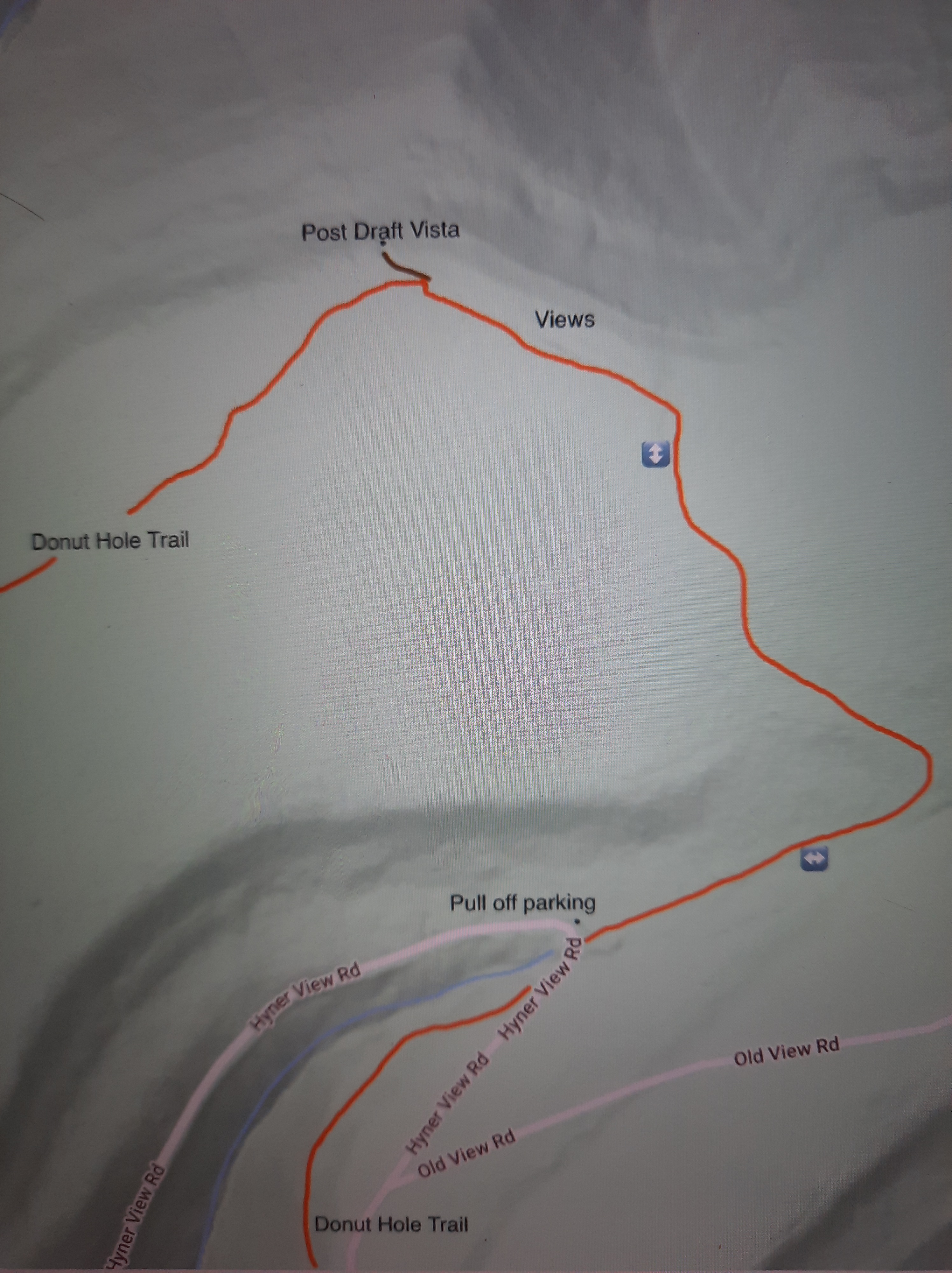
Parking: pull off parking at about 41.339445, -77.611247.
Highlights: great views, mountain laurel, ferns, fall foliage
Description: This short and easy trail leads to a great view of the Sproul State Forest. Located near famous Hyner View, expect to have this view all to yourself. This is an out and back trail along the Donut Hole Trail (DHT). The terrain is easy, with a mild climb. The trail meanders through mountain laurel and across some fern meadows. The forest is mostly hardwoods.
Turn left along a pipeline swath that resembles a mountaintop meadow. Enjoy nonstop views as you hike along the swath. There are also wildflowers. The DHT turns left into the woods, but continue off trail along the swath for about 200 feet to Post Draft Vista. The view is beautiful as it looks into a deep, wooded gorge. There is a campsite. Sunsets must be incredible. Return the way you came.
When we hiked in mid-June, the mountain laurel was in bloom, making for a beautiful hike.
This map is for general directional purposes only, it is not a GPS route. Brown is the short off trail section along the pipeline swath to the view.Donut Hole Trail
Highlights: Several great views, cascades on Huff Run, meadows, wildflowers, well built trails
Parking: 41.327746, -77.634180 . Don’t be tempted to park at Hyner View, earn the view. Do the climb.
Direction of description: Counterclockwise. I think it is better to climb up to Hyner View then descend.
Issues: Some sections going up to Hyner View are steep. Nettle can be an issue along Huff Run in summer.
Description: This hike needs to be on your list, I enjoyed it very much. It offers both challenge and easy, cruisey sections. And there are views, several more than the famous one at Hyner View. The descent along Huff Run is pure hiking bliss.
Hyner View has become a trail running hotspot. The PA Trail Dogs have done an amazing job building a network of superb trails around Hyner View, creating excellent hiking opportunities. Thier trails are often well built and a pleasure to hike. I hope to explore more of these trails in the future. Try to avoid hiking on their race weekends. Thank you to the PA Trail Dogs for all the work they do.
From the parking area, walk to the end of the road and pick up Cliffhanger. Then turn left onto Carl’s Way, which curves and makes a steady climb up the mountain. There are some views through the trees. Reach a T intersection with Escarpment and the Donut Hole Trail (DHT). Escarpment is blazed yellow and the DHT is orange. The DHT is about a hundred miles long. Here, I suggest a side hike to the right to see excellent views of the river and mountains from ledges. These views are great for a sunset. Return the way you came.
Back on the loop, start the long climb up to Hyner View on the DHT and Escarpment trails. Cross meadows and glades with wildflowers. The DHT appears to separate to the right; it is best to go straight on the yellow trail. The climb steepens and there are more fine views to the south and west.
Reach a meadow area with more views. Enter the woods for another steep push. Break out of the trees and hike up the large meadow that surrounds Hyner Vista. This is pretty dramatic, with views in all directions. Reach Hyner Vista and take pride in your climb; this is by far the best way to experience this famous view.
Turn right on the park road, and then right onto the new Ligenza Trail, blazed yellow. This easy trail explores the woods with ferns. As you near the northern end, the Ligenza Trail follows an old forest road and blazes are few, but the route is obvious. Turn right on Old View Road, a dirt road, hike a short ways, then make a right onto Cleveland Hollow Trail. There is a sign.
Cleveland Hollow Trail is an obvious old woods road; there may be faded yellow blazes. Reach the DHT and turn left. Hike through the woods with laurel and reach Hyner View Road, turn left, follow it a short ways, then turn right on the Huff Run Trail (also the Garby, Paulhamus, and Donut Hole trails).
Descend this yellow trail. This trail is pure hiking bliss. The trail is beautifully built with view of the cascading creek and the deepening gorge. Huff Run has no tall falls, but many small cascades and falls. It is a joy to hike along it. There are spring wildflowers along Huff Run. Cross the run on a footbridge and reach the road. Turn right to the parking area.
Congratulations on making the climb up to Hyner View!
View from the Escarpment/Donut Hole TrailsHuff RunThis map it for general directional purposes, it is not a GPS route.
Blazes: Lower Pine Trail is red, remainder of trails are yellow.
Description: The Pine Creek Gorge in the Tiadaghton State Forest is home to many hiking trails and this is one that should be on your list. Park at the forest headquarters which has its own views and wildflower meadows. If the building is open, be sure to check it out to see the displays and a balcony with a green roof and more views.
The red Lower Pine Trail begins at the end of the parking area and descends in a pine forest. Reach Lower Pine Bottom Run with a small cascade and hike the edge of the giant arched concrete culvert. Reach Lower Pine Bottom Road and turn right. Hike up the road a short distance. Turn left at a trail sign, which calls the Eiger Trail the “Quadfather”, you’ll soon see why. Hike behind a cabin and reach the beginning of the loop, continue on the Eiger Trail as it follows an old grade through laurel. The grade steepens as it climbs the flank of the mountain. Begin to pass old quarries and ledges.
The trail eases as it follows the grade along the steep slope of the mountain. I liked this part as the trail offered such forgiving tread across steep terrain. The forested slopes just fall away. Reach a large quarry and more ledges. The ledges continue before the trail begins a series of well built switchbacks up through the laurel.
Finally, the trail levels off at the top and you soon reach Bull Run Vista, an impressive view of the Pine Creek Gorge. The vast plateau is incised with many gorges and glens. Pine Creek is about 1,200 feet below.
Now begin the Log Slide Trail through mountain laurel. This trail would be beautiful in late June when the laurel blooms. The trail then begins its descent on an old log slide, which is somewhat gradual. Hike through groves of hemlocks with moss. Pass an old stone retaining wall for the slide. Reach the end of the loop and retrace your steps. The Log Slide Trail is easier than Eiger, but both are worth hiking.
Length: Approx. 6-7 miles in total to the falls and vista.
Blazes: Mid State Trail is orange, Gamble Run Trail is red.
Parking: Small lot at 41.242016, -77.334424.
Trail conditions: Good. Trails are well blazed and easy to follow.
Highlights: Cascades, small falls, pools, streamside hiking, hemlocks, vista, beautiful gorges.
Issues: Hike up to the vista is steep and rugged.
Level of challenge: Easy to difficult
Description: I really enjoyed this hike and look forward to returning. It is yet another gem in the Pine Creek Gorge region. This is an out and back hike to both the falls and vista. Part of this hike follows the Mid State Trail (MST) the longest trail in the state and a part of the Great Eastern Trail, which goes from Alabama to New York.
From the parking area, hike up and around the meadow with some nice views on the Gamble Run Trail. Expect wildflowers in summer. This meadow really reminded me of the Appalachian Trail in Virginia during my thruhike this year. Drop down and follow an old grade. At first it is well above the creek, but it gradually comes closer. Along the way, the MST joins. Gamble Run nears the trail and it is adorned with cascades and pools of clear water. There is moss, ferns and hemlocks. The cascading water accompanies the trail as you gradually hike up.
Reach Schultz Fork where the MST turns right and begins the climb. Here, Gamble Run has a beautiful slide and deep pool. This is a gorgeous spot. Continue on the red Gamble Run Trail into the scenic gorge. The cascades, ferns, and moss provide the scenery. Up ahead you’ll notice a large ledge with a deep pool; the creek slides through a narrow chasm. This is Gamble Run Falls. Not more than ten feet tall, it is quite beautiful as the water has sculpted the bedrock. While the Gamble Run Trail continues, turn around here and return to the MST at Schultz Fork.
Now begins the climb into this rugged gorge. Schultz Fork is seasonal, but has a variety of beautiful cascades and small waterfalls when flowing. Seeing and hearing the water eases the climb. The trail steepens and moves from the creek. Reach the heart of the rugged gorge where two branches meet and a cliff looms on the other side. The MST turns left and makes a final climb; if the trees are bare, the rugged gorge spreads before you.
The MST makes a sharp right turn. Here, look for faded blue blazes on the left. Follow this trail a few hundred feet through the laurel and reach beautiful Gamble Run Vista (or Schultz Fork Vista) from a ledge. Overlook the deep gorges and tiers of ridges with no signs of development or traffic. It is a glorious window into the wilderness and well worth the climb to see a view most hikers probably miss. This is an ideal sunrise vista. Hidden gems like this vista make hiking so rewarding and underscore the beauty of the MST. From here, retrace your steps to the parking area.
Cascades, falls, pools, moss, ferns, hemlocks, meadows, and a wilderness vista, what more do you want on a hike?
This map is for general directional purposes only, it is not a GPS track.